
September 10, 2026
Weighing the Carbon of Forest Giants
An AI model of unprecedented precision, developed by the teams of IVADO researchers David Rolnick and Etienne Laliberté, can now estimate both the species and the height of a tree from a single drone photo. The advance could help determine more quickly whether a forest absorbs more carbon than it releases, a figure that shapes climate policy decisions.
An ordinary drone photo can accurately estimate the elevation of the canopy top, but not that of the ground, which remains largely hidden beneath the trees. Yet a tree’s height is calculated from the difference between these two elevations.

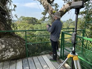
“The problem is that we don’t know the ground elevation in most of the world’s forests,” says Etienne Laliberté.
Alternative solutions remain costly: measuring each tree on the ground takes an enormous amount of time, and lidar, a laser-scanning technology that captures ground elevation well, requires equipment that most of the world’s forests have never had access to.
“The largest trees store half of a forest’s carbon,” explains Etienne Laliberté, who is also a professor in the Department of Biological Sciences at Université de Montréal. “They can live for hundreds of years. And we know very little about how they respond to climate change.”
These carbon giants are also the least studied, because they are too rare to be sampled in sufficient numbers. The model, called DINOvTree, sidesteps the ground-elevation problem by estimating height directly from the image.
Another common workaround infers height from crown width, which is visible from the air. It remains unreliable: in temperate forest, its error is nearly three times that of the new model, even under the most favorable conditions, when the tree’s species and outline are already known.
Tree Height Estimation
| Forest type | DINOvTree-L average height error | Traditional method average height error |
|---|---|---|
| Temperate — average tree height: 14.2 m | 1.12 m | 2.98 m |
| Tropical — average tree height: 29.1 m | 2.75 m | Parameters not established |
The average error indicates by how many meters the estimate deviates, on average, from actual height. Because tropical trees are roughly twice as tall, the two rows are not directly comparable. The traditional method, an equation based on crown width, does not apply in tropical forest, since established parameters do not exist for most species.
Source: paper presenting the DINOvTree model, by Jannik Endres, Étienne Laliberté, David Rolnick, and Arthur Ouaknine. The results reported are those of DINOvTree-L, the larger of the model’s two versions.
Work Impossible at Human Scale
Taxonomic identification remains a separate, equally limiting problem: the leaves, flowers, and fruit needed to distinguish a species are often invisible from the ground, beneath a canopy dozens of meters high.
In the field, a traditional inventory remains slow: two people take 30 minutes to an hour to cover a 20-by-20-metre plot in Quebec forest, and species identification alone can take months on a one-hectare tropical plot.
Was what his team accomplishes today humanly possible before these tools existed? Etienne Laliberté is unequivocal.
“It’s absolutely impossible. It would take 1,000 people to do it, and even then, they would have to be 1,000 experts.”
From XPRIZE to DINOvTree
This capability is a recent addition, separate from the crown-detection model the team has used since 2024. That earlier technology, a method for detecting and mapping tree crowns by drone, led the team to victory at the international XPRIZE Rainforest competition in 2024, under the name Limelight Rainforest.
The technology was developed by the team with support from IVADO’s AI, Biodiversity and Climate Change program, now continued under the Environment cluster of the IAR³ program. DINOvTree now builds on that foundation; the paper presenting it is led by researcher Jannik Endres, with Étienne Laliberté, David Rolnick, and Arthur Ouaknine as coauthors, and has been accepted at the ECCV 2026 conference.
The team deliberately designed these tools to run on consumer-grade hardware. “It’s one line of code,” says Arthur Ouaknine. “You install a package, and with that single line, you can run the whole model on your own computer.” The choice responds directly to requests from field ecologists the team was already working with, notably in Brazil, Ecuador, and Panama.
DINOvTree identifies species and height from the same image, two tasks handled jointly for the first time, according to the authors.
What Still Eludes the Model
In tropical forest, the traditional method could not even serve as a benchmark for assessing height: it requires parameters calculated species by species, and that data does not yet exist for most tropical trees.
“I think of the different maple species,” says Arthur Ouaknine. “If you don’t catch the right moment, the colours for instance, they’re very hard to tell apart, and even for ecologists, visually, it’s complicated.”
What Must Be Proven to Protect a Forest
The stakes are also political. To convince authorities that a forest plot deserves protection, a community must typically document two things: the biodiversity it contains and the amount of carbon its trees absorb. “In practice, you need ecologists to go into the field, measure the trees, and carry out inventories,” explains Arthur Ouaknine, the project’s co-director. This automated monitoring makes that kind of demonstration possible in regions where it was previously out of reach, notably in the tropics.
The team is now looking to extend its partnerships beyond the XPRIZE test plot, including outside tropical forest, in particular for monitoring plantations in Quebec’s boreal forest.
Two sectors are already asking for this kind of large-scale segmentation and species estimation, according to Arthur Ouaknine: the reforestation industry and maple syrup producers, who are looking to maintain the biodiversity of their forests.
For Étienne Laliberté, the success of the next stage will not be measured by the number of new research projects, but by a software product accessible enough for new partners to become self-sufficient within months, rather than depending on the individualized support that currently takes several months per site.
Still, this kind of documentation remains out of reach in most tropical forests. “We’d like to do it, we want to know the species, but we can’t because it would cost a fortune,” says Étienne Laliberté. “We’d have to send experts all over the Amazon, and there are almost no experts, they aren’t available.”
Funding for this work remains unevenly distributed: researchers based in tropical regions have less access to it.
“Everyone benefits from the fact that there are healthy tropical forests on the planet,” says Étienne Laliberté. “They regulate the global climate. So they need to be studied.”
About this Study
The paper “Estimating Individual Tree Height and Species from UAV Imagery,” by Jannik Endres, Etienne Laliberté, David Rolnick and Arthur Ouaknine, was presented at the European Conference on Computer Vision in September 2026.
